GPS-Tracker Capturs Endurance GSM
139€ zzgl. MwSt.
+ Wahl des SIM-Karten-Abonnements (Europa/Welt)
Oder zahlen Sie gebührenfrei in 4x mit ![]()
● Capturs Endurance GSM GPS-Tracker
● Multi-Betreiber SIM-Karte GSM – LTE
● Abonnement “High Autonomy” – max. 2 Positionen pro Tag
● Zugang zur Capturs Premium Plattform/Anwendung und API
● 20 SMS
● Multi-Betreiber SIM-Karte GSM – LTE
● Abonnement ” High Autonomy ” – max. 2 Positionen pro Tag
● Zugang zu einem Booster (mehrere Positionen) im Falle eines Diebstahls
● Europa oder weltweit
● 1 Jahr ohne Verpflichtung. Für ein kürzeres oder längeres Abonnement, kontaktieren Sie uns bitte.
● Capturs Endurance GSM GPS-Tracker: 139€ zzgl. MwSt. pro Stück
● Europa-Abonnement: 2,99€ zzgl. MwSt./Monat (35,88€ zzgl. MwSt./Jahr)
● Weltweites Abonnement (Option): 8,99€ zzgl. MwSt./Monat (107,88€ zzgl. MwSt./Jahr)
⚠ Mengenrabatte: Kontaktieren Sie uns
Alles inklusive ✓
Aktivierte Multioperator-SIM-Karte im Lieferumfang enthalten
Nutzen Sie die Vorteile des GSM-Netzes und aller in Europa oder weltweit verfügbaren Betreiber, je nach Wahl der SIM-Karte.

Siehe
technisches Blatt

Noch Fragen?
Kontaktieren Sie uns

Multi-Betreiber
Inklusive SIM-Karte

GSM-Netz (alle Betreiber eingeschlossen)

Mengenrabatte:
bitte angeben
Siehe technisches Blatt
Noch Fragen?
Kontaktieren Sie uns
Multi-Betreiber
Inklusive SIM-Karte
GSM-Netz (alle Betreiber eingeschlossen)
Mengenrabatte:
bitte angeben
Ein robuster GPS-Tracker mit langer Batterielebensdauer.
Der GPS-Tracker eignet sich für eine Vielzahl von Situationen, die eine lange Akkulaufzeit und eine tägliche Ortung erfordern.
▶️ Verfolgung in Echtzeit
Die Live-Positionen werden mit der programmierten Frequenz gesendet. Die Grundkonfiguration des Endurance GSM GPS-Trackers sieht vor, dass 2 Positionen pro Tag gesendet werden (wir können diese Konfiguration manuell ändern, indem wir die Intervalle nach Bedarf staffeln).
Eine globale Ansicht ermöglicht es Ihnen, den Standort all Ihrer Capturs GPS-Tracker zur gleichen Zeit zu sehen (unabhängig vom Modell). Profitieren Sie von einer detaillierten Ansicht jedes Ihrer Capturs-GPS-Tracker, die Ihnen Informationen sowie alle zugehörigen Trajektorien und Haltepunkte in Echtzeit auf der Capturs-Schnittstelle (mobile Anwendung oder Web-Plattform) liefert.
Die Positionen und Trajektorien können im GPX-Format von der Capturs-Plattform exportiert werden.
▶️ GSM LTE Netz
Wir liefern SIM-Karten für mehrere Netzbetreiber, die bereits vorinstalliert und bei Versand in Ihren GPS-Trackern aktiviert sind. Der GPS-Tracker Endurance GSM Capturs nutzt das GSM-LTE-Netz.
▶️ Lebensdauer der Batterie
Die Batterielebensdauer des Capturs Endurance GSM GPS-Trackers variiert zwischen 3 und 5,5 Jahren, abhängig von der Nutzung und der Anzahl der pro Tag gesendeten Positionen.
| Verwenden Sie | Lebensdauer der Batterie |
| 1 Position / Tag | 5.8 Jahre |
| 2 Positionen / Tag | 3.2 Jahre |
| 3 Positionen / Tag | 2.2 Jahre |
▶️ Wasserabdichtung
Der GPS-Tracker ist nach IP67 klassifiziert: kein Eindringen von Staub, vollständiger Schutz gegen Berührung (staubdicht). Kein Eindringen von Wasser, wenn er 30 Minuten lang bis zu einer Tiefe von 1 Meter untergetaucht wird.
▶️ SMS- und/oder E-Mail-Warnungen erstellen
Konfigurieren Sie verschiedene Arten von SMS-/E-Mail-Warnungen über die Capturs-Oberfläche: Zoneneintritt, Zonenaustritt, Bewegungserkennung, Immobilität, Abwesenheit, schwache Batterie und Tastenklick. Sie können den Inhalt der Alarme ändern und die Empfänger Ihrer Wahl eingeben.
▶️ Kursverläufe und Positionen teilen
Generieren Sie selbst einzigartige URLs und teilen Sie diese mit so vielen Personen wie Sie möchten. Ändern Sie die Parameter und behalten Sie die Kontrolle: Aktivierung/Deaktivierung, Löschung, Länge der zu teilenden Flugbahn usw.
▶️ Erweiterte Analysen generieren
Erstellen Sie automatische Berichte zu allen Ereignissen auf Ihren Capturs GPS-Trackern: Positionen, Alarme, Zonen, Bewegungen, Stopps, Temperatur usw. Erstellen Sie benutzerdefinierte Dashboards und Diagramme. Exportieren Sie Daten im CSV-Format zur weiteren Verarbeitung.
▶️ Berichte über Zonenein- und -ausgänge
Erstellen Sie Ihre eigenen virtuellen Zonen mit unserem benutzerdefinierten Zonenerstellungstool. Zeigen Sie Ihre Zonen auf der Karte in verschiedenen Farben an. Verknüpfen Sie diese Zonen mit Warnmeldungen, um Nachrichten zu erhalten, wenn ein GPS-Tracker eine Zone betritt oder verlässt. Erstellen Sie automatisch Berichte über das Betreten und Verlassen von Zonen und exportieren Sie diese zur Datenanalyse.
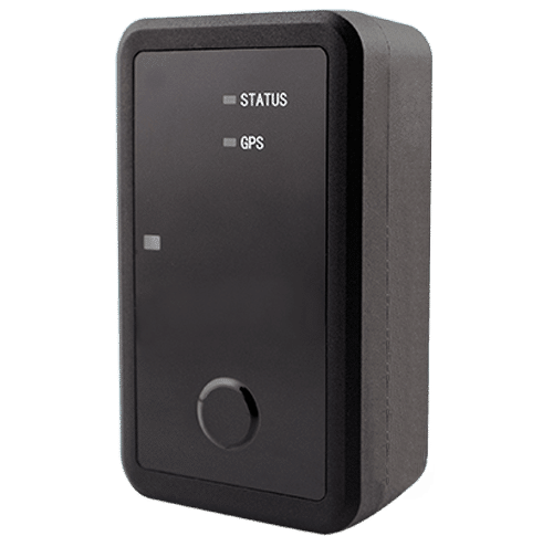
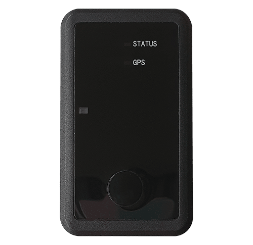
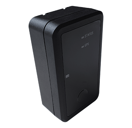
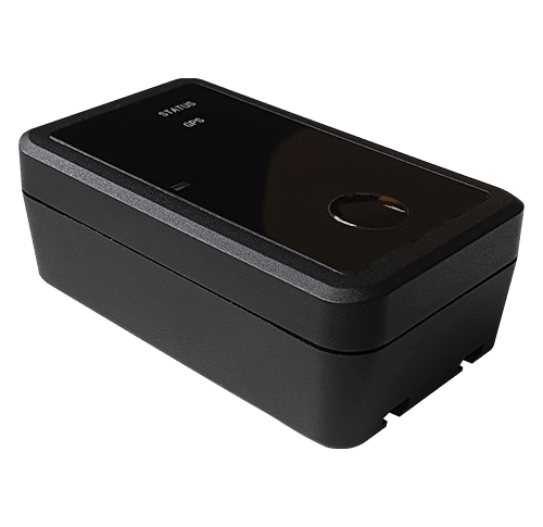
Länge 85mm | Breite 49mm | Höhe 30mm
Gewicht 140g
Stromversorgung – austauschbarer 1400mAh-Akku.
GSM LTE Netzwerk
Maximal 2 Positionen pro Tag – Konfigurierbar nach Kundenwunsch
IP67
Überwachung von Großgeräten oder Anlagen über große Entfernungen. Überwachung der Lieferkette.
Kann auch zur Vorbeugung von Diebstahl eingesetzt werden, dank des Boosters, der es Ihnen ermöglicht, mehr Positionen zu erhalten, wenn ein Diebstahl entdeckt wird.
Die Capturs-Plattform: einfach und leistungsstark
Greifen Sie von Ihrem Computer, Tablet oder Smartphone aus auf die Connect-Schnittstelle oder die mobile Capturs-Anwendung zu.
Erfahren Sie mehr über die Echtzeit-Tracking-Plattform Capturs und alle damit verbundenen Funktionen.
Greifen Sie über Ihr Smartphone (App verfügbar für Android und IoS), Tablet oder Computer auf die Capturs-Plattform zu.
Verwalten Sie alle Ihre GPS-Tracker in Echtzeit, stellen Sie Alarme ein, erstellen Sie unendlich viele benutzerdefinierte Zonen und generieren Sie Berichte für eine gründliche und detaillierte Analyse.
Frequently asked questions.
Um mehr über den Capturs Model Endurance GSM GPS-Tracker zu erfahren, kontaktieren Sie uns oder konsultieren Sie die FAQ.
GPS tracker Capturs Endurance GSM
2 – Click on the button + to access to the addition of the new device.
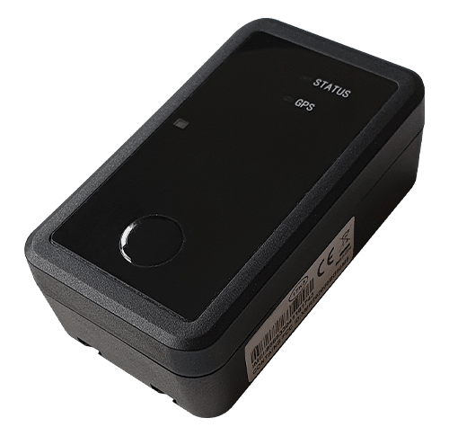
3 – Complete the serial number (S/N) and the activation key (Key) indicated on the back of the device.
(It is normal that the first letter (A or B) of the S/N does not then appear in the device name because it is the device’s model indicator.)
or
Click on the QR code icon and scan the back of the device.
Capturs GPS trackers can only be registered to one user account. If you try to add them to a second account, this message will appear. You will need to delete it from the old account before you can register it to a new one.
2 – To change the name of your GPS tracker, click on the icon

3 – To change the picture of your GPS tracker, click on the icon


In order to send an alert, you have to create one and configure it.
Enter the email addresses and/or phone numbers of your relatives in the configuration of your alert.
To send an alert, you must be in an area covered by the Sigfox network or by GSM (depending on the model).
2 – Choose the GPS tracker you want to configure.
3 – To create a new alert, click on

4 – Click on the icon

Possible configurations:
– Add a name to the alert.
– Enable automatic reactivation of the alert.
– Create time slots for triggering alerts.
– Choose the type of sending of the alert (SMS, Email, API Callback)
Alert content:
– Add one or more Emails, phone numbers, etc..
– Customize the subject and content of the alert as you wish.
– Check the “Share link activated” case if you want to share your tracking link in the alert.
For area alerts:
– Customize the zones by pressing the dots around the red zone.
– Create round or polygonal areas.
– Capturs Systems Connect specific: select an area already registered in the library.

Just click on the button in the middle of the GPS tracker according to the chosen alert (1 click, 2 clicks, 4 clicks or a long click). The blue led at the bottom left of the GPS tracker will blink as many times as you clicked on the button.
If it is the 3 clicks alert :
In the case of the 3-click alert, there is an acknowledgement function: after pressing the button 3 times, the “red” and “green” leds will start flashing alternately until the acknowledgement is received, where the green led will flash rapidly. If this is not the case, the red led will blink quickly and the GPS tracker will try to send the alert again 10 minutes later and start blinking alternately until validation or not of the data reception.
If it is a area alert:
Your alert is sent automatically when your GPS tracker (device or smartphone) enters or leaves the area you have configured.
If it is a motion alert:
When your device is stationary and hasn’t moved for a while, your motion alert will be triggered when the tracker’s motion is detected.
If it is a no motion alert:
An alert will be sent when the GPS tracker has been stationary for a set time.
If it is a low battery alert:
An alert will be sent when the battery is less than 20% of its capacity.
If it is a power-off alert:
An alert will be sent when the GPS tracker is turned off, i.e. when someone turns it off.
If it is an unplugging alert:
An alert will be sent when the GPS tracker is unplungged.
If it is an absence alert:
An alert will be sent when the GPS tracker is not present in a predefined area at the scheduled time.
If it is a temperature alert:
An alert will be sent when the temperature is below or above a certain set temperature threshold.
To start a live tracking using your Capturs GSP tracker, you need to have it registered on your Capturs account and to have an active subscription for real-time data transmission.
2 – Click on the button + to access to the addition of the new device.
3 – Complete the serial number (S/N) and the activation key (Key) indicated on the back of the device.
(It is normal that the first letter (A or B) of the S/N does not then appear in the device name because it is the device’s model indicator.)
or
Click on the QR code icon and scan the back of the device.
Capturs GPS trackers can only be registered to one user account. If you try to add them to a second account, this message will appear. You will need to delete it from the old account before you can register it to a new one.
Then simply take it with you or fix/place it. The device must be on and with battery to send its position when it is in motion.
The Capturs OBD GPS Tracker must be connected to the vehicle’s OBD II socket and the Capturs Power GPS Tracker must be connected to the vehicle battery.
If the GPS trackers are transmitting well but no positions are being sent at the same time, this may be due to several phenomena specific to devices using satellite positioning systems.
The main losses of positions come from the signals dropping out between the GPS tracker and the satellites, thus preventing the triangulation of the position:
– From GPS fix just after departure, cold, where the GPS plotter could not see the constellation of satellites, and therefore needed about 3 minutes before starting to move to find the position and thus start to fix its position correctly.
– The outdoor environment: trees, buildings and even clouds can prevent the proper reception of data from a satellite and may cause triangulation to be prevented or accuracy to be lost.
GPS Tracker Model B:
A simple press on the central button of the tracker allows it to be switched on, if there is enough battery, and to start sending positions in real time.
To turn off the tracker, you must keep the button pressed for about 5 seconds. The leds of the tracker will have the following behaviour: after 3 seconds the blue led will light up, then by keeping pressed, the red led will light up about 2 seconds later. You can release the button when the tracker is off.
GPS Tracker Model C/C Beehive:
If the battery is inserted, the GPS tracker starts automatically. If a tab is fitted to the GPS tracker, gently pull it out and gently tighten the 4 screws (standard Model C) to close the case properly.
To turn off the GPS tracker, remove the battery.
GPS Tracker OBD:
To turn the GPS tracker on and off, simply plug and unplug it from the vehicle’s OBD II socket.
GPS Tracker Power:
To turn the GPS tracker on and off, simply plug and unplug it from the vehicle’s battery.
GPS Tracker Performance GSM:
To switch the GPS tracker on and off, simply press and hold the button on the edge for about 5 seconds.
GPS Tracker Endurance GSM/Mini:
To switch the GPS tracker on and off, open the case and press the ON/OFF switch located inside.
Battery life varies according to the use and stops of the Capturs GPS trackers. It can also vary according to the configurations made by our teams or by yourself on the Capturs software (only available for the Model B or Model A). It can be up to several months/years.
The battery life of the Capturs OBD and POWER GPS trackers is unlimited as it is linked to that of the vehicle.
| GPS tracker model | Estimated battery life |
| Model B Performance GSM |
★★★★☆ |
| Model C Model C Beehive Endurance GSM Mini |
★★★★★ |
| OBD Power |
ထ |
Estimated battery life by model :
Model B
Performance GSM
★★★★☆
Model C
Model C Beehive
Endurance GSM
Mini
★★★★★
OBD
Power
ထ
| Model B | 68 x 42 x 24 mm | 55g |
| Model C | 75 x 75 x 35 mm | 60g |
| Model C Beehive | 87 x 57 x 24 mm | 60g |
| Performance GSM | 39 x 26 x 77 mm | 93g |
| Endurance GSM | 85 x 49 x 30 mm | 140g |
| Mini | 64 x 50 x 22 mm | 82g |
| OBD | 48 x 48 x 22 mm | 58g |
| Power | 135 x 65 x 15 mm | 130g |
Model B GPS tracker: Measures 68x42x24mm and weighs 55g.
Model C GPS tracker: Measures 75x75x35mm and weighs 60g.
Model C Beehive GPS tracker: Measures 87x57x24mm and weighs 60g.
Performance GSM GPS tracker: Measures 39x26x77mm and weighs 93g.
Endurance GSM GPS tracker: Measures 85x49x30mm and weighs 140g.
Mini GPS tracker: Measures 64x50x22mm and weighs 82g.
OBD GPS tracker: Measures 48x48x22mm and weighs 58g.
Power GPS tracker: Measures 135x65x15mm and weighs 130g.
The Model B (and A) Capturs GPS tracker is not waterproof and has no IP certification, but we provide with each GPS tracker a waterproof pouch that allows the GPS tracker to be sheltered from water.
The Model C Capturs, Endurance GSM, Mini and Power GPS trackers are certified IP67. They are waterproof, dustproof and weather resistant.
Please note that the Model C Beehive GPS tracker is not waterproof, unlike the standard Model C.
The GPS tracker Capturs Performance GSM is IPX5 certified. It is protected against water splashes from all directions.
LED Status:
| Searching network | ● fast flash |
| Registered to network | ● slow flash |
| SIM is locked by PIN | ● fixed |
| Not connected to network | ● dark |
LED GPS:
| GPS fix in progress | ● fast flash |
| Successful GPS fix | ● slow flash |
| GPS is off | ● dark |
Power on, Power off and operation:
| During power on | Both the LEDs will be on to indicate the tracker is being powered on. |
| When checking the traceur status | Both the LEDs will be on to indicate the tracker still works. |
| During power off | Both the LEDs will flash simultaneously to indicate the tracker is being powered off. |
LED Status:
● fast flash: Searching network
● slow flash: Registered to network
● fixed: SIM is locked by PIN
● dark: Not connected to network
LED GPS:
● fast flash: GPS fix in progress
● slow flash: Successful GPS fix
● dark: GPS is off
Power on, Power off and operation:
During power on: Both the LEDs will be on to indicate the device is being powered on.
When checking the tracker status: Both the LEDs will be on to indicate the device still works.
During power off: Both the LEDs will flash simultaneously to indicate the device is being powered off.
| Model B | Live geolocation: 10 min / Tracking accuracy: 3 min (1) |
| Model C / C Beehive | Live geolocation: 15 min / Tracking accuracy: 5 min |
| Performance GSM | Live geolocation: 60 s / Tracking accuracy: 60 s (2) |
| Endurance GSM | Live geolocation: 2 positions/day / Tracking accuracy: 2 positions/day (2) |
| Mini | Live geolocation: 2 positions/day / Tracking accuracy: 2 positions/day (2) |
| OBD | Live geolocation: 30 s / Tracking accuracy: 30 s |
| Power | Live geolocation: 30 s / Tracking accuracy: 30 s |
(2) It is possible to change this frequency through our support team. Please note that the higher the frequency, the less time the battery will last.
Model B:
Live geolocation: 10min / Tracking accuracy: 3min (1)
Model C / C Beehive:
Live geolocation: 15min / Tracking accuracy: 5min
Performance GSM:
Live geolocation: 60s / Tracking accuracy: 60s (2)
Endurance GSM:
Live geolocation: 2 positions/day / Tracking accuracy: 2 positions/day (2)
Mini:
Live geolocation: 2 positions/day / Tracking accuracy: 2 positions/day (2)
OBD:
Live geolocation: 30s / Tracking accuracy: 30s
Power:
Live geolocation: 30s / Tracking accuracy: 30s
(1) It is possible to increase this frequency in the PC/Mac Capturs software by connecting your Model B GPS tracker to your computer.
(2) It is possible to change this frequency through our support team. Please note that the higher the frequency, the less time the battery will last.
You can send different types of alerts depending on your tracker.
Model B (or A) GPS tracker: Area entry, area exit, motion detection, no motion, powering-Off, absence, 3 press button, 1 press button, 2 press button, 4 press button, 1 long press button and low battery.
Model C GPS tracker: Area entry, area exit, motion detection, no motion, absence, low battery.
Performance GSM, Endurance GSM, Mini GSM GPS trackers: Area entry, area exit, motion detection, no motion, absence, low battery, 1 long press button.
OBD GSM, Power GSM GPS trackers: Area entry, area exit, motion detection, no motion, absence, unpluging.
Smartphone tracker via Capturs application: Area entry, area exit, motion detection, no motion.
Capturs Systems Connect interface specific functions
How do I access it?
1 – On the Capturs interface, open the left menu and click on Analytics.
2 – Go to the advanced analyses: select date, zone and tracker. Scroll through the different tables and graphs by clicking on < > at the bottom of the page. Click on Google Data Studio at the bottom of this page for additional analyses.
You don’t have access to this feature? Contact support@capturs.com.
2 – Click on the button + to access to the addition of the new area.
3 – Create a specific area by moving the points that surround it, give it a name, a color and validate. Create all the areas you need this way.
4 – All the areas you created are now on the map at the top of this same page. They are also saved in the library of your account in order to reuse them by creating area alerts.
5 – The check in / check out table is at the bottom of the same page. It allows you to have precise data on the trackers that have entered or left these areas, as well as the times and dates.
2 – Select a tracker in the search bar to bring up the table.
3 – Click on

4 – You can now analyze the table and graphs that correspond to the raw data emitted by your tracker. These are doubts the data sent by the tracker to each event received by the tracker.
Points of Interest (POIs) are your own landmarks. You can easily create them by entering a street address or by pointing to the map. They will be displayed on the map if you select the “points of interest” icon on the right side of the screen. Also, easily find your points of interest on the map by filtering them using the top bar that appears when you have saved POIs.
With the “Labels” tool, customize your points of interest even better by categorizing them with colors.
When you click on 
2 – You have access to the following reports: alerts, check-in/out, raw data, stop points and analytics.
3 – You can export the data by clicking on CSV EXPORT.
Das Beste aus dem GSM-Netz.
Die beste Netzabdeckung der Welt. Wählen Sie die richtige SIM-Karte für Ihre Reisen: Europa oder weltweit.

Länder, die im Europa-SIM-Abonnement enthalten sind: Belgien, Bosnien und Herzegowina, Bulgarien, Dänemark, Deutschland, Estland, Finnland, Frankreich, Französisch-Guayana, Gibraltar, Griechenland, Irland, Island, Italien, Kosovo, Kroatien, Litauen, Luxemburg, Malta, Mayotte, Niederlande, Norwegen, Österreich, Polen, Portugal, Réunion, Rumänien, Schweden, Schweiz, Slowakei, Slowenien, Spanien, Tschechische Republik, Ukraine, Ungarn, Vereinigtes Königreich, Zypern.
Länder, die im World SIM-Abonnement enthalten sind (einschließlich der Länder in der Zone Europa): Afghanistan, Albanien, Algerien, Angola, Anguilla, Antigua und Barbuda, Argentinien, Armenien, Aruba, Australien, Österreich, Aserbaidschan, Bahamas, Bahrain, Bangladesch, Barbados, Belarus, Belgien, Belize, Benin, Bermuda, Bhutan, Bolivien,; Bonaire, Bosnien und Herzegowina, Botswana, Brasilien, British Vingin Islands, Brunei, Bulgarien, Burkina Faso, Burundi, Kambodscha, Kamerun, Kanada, Kap Verde, Kaimaninseln, Zentralafrikanische Republik, Tschad, Chile, China, Kolumbien, Kongo, Costa Rica, Elfenbeinküste, Kroatien, Zypern, Tschechische Republik, Demokratische Republik Kongo, Dänemark, Ägypten, Dominica, Dominikanische Republik, Ecuador, El Salvador, Äquatorialguinea, Estland, Färöer-Inseln, Fidschi, Finnland, Frankreich, Französisch-Guayana, Französisch-Polynesien, Gabun, Gorgia, Deutschland, Ghana, Gibraltar, Griechenland, Grönland, Guam, Guatemala, Guinea, Guinea-Bissau, Guyana, Honduras, Hongkong, Island, Indien, Indonesien, Irland, Isle of Man, Israel, Italien, Jamaika, Japa, Ungarn, Zypern