Capturs Model B GPS-Tracker
Out of stock
+ Wahl Abonnement Capturs/Sigfox ab 2,29€ zzgl. MwSt/Monat
Oder zahlen Sie gebührenfrei in 4x mit ![]()
Abonnement für 2,29€
zzgl. MwSt. /Monat 3
Jahre Verpflichtung
Abonnement für 2,69€
zzgl. MwSt. /Monat 2
Jahre Verpflichtung
Abonnement für 2,99€
zzgl. MwSt. /Monat 1
Jahr Verpflichtung
● Capturs Model B GPS-Tracker
● Capturs/Sigfox Abonnement – beliebige Dauer
● Zugang zur Capturs Premium-Plattform/Anwendung und API
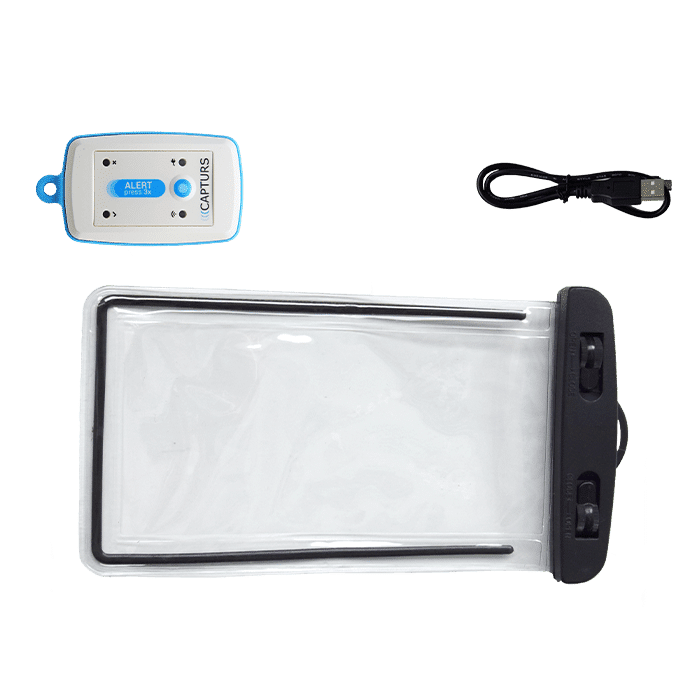
● Micro-USB-Kabel
● Wasserdichter Beutel
● 20 SMS
● Capturs/Sigfox Abonnement – 1, 2 oder 3 Jahre
● Konsultieren Sie die Sigfox-Abdeckungskarte
● Unverbindlich.
● Capturs Model B GPS-Tracker: 114€ zzgl. MwSt. pro Stück
● Capturs/Sigfox Abonnement: ab 2,29€ zzgl. MwSt./Monat
⚠ Mengenrabatte: Kontaktieren Sie uns

Capturs Model B GPS-Tracker
114€ zzgl. MwSt.
Out of stock
Oder zahlen Sie gebührenfrei in 4x mit ![]()
Abonnement für 2,29€ zzgl. MwSt./Monat mit 3 Jahre Verpflichtung
Abonnement für 2,69€ zzgl. MwSt./Monat mit 2 Jahre Verpflichtung
Abonnement für 2,99€ zzgl. MwSt./Monat mit 1 Jahr Verpflichtung
● Capturs Model B GPS-Tracker
● Capturs/Sigfox Abonnement – beliebige Dauer
● Zugang zur Capturs Premium-Plattform/Anwendung und API
● Micro-USB-Kabel
● Wasserdichter Beutel
● 20 SMS
● Capturs/Sigfox Abonnement – 1, 2 oder 3 Jahre
● Konsultieren Sie die Sigfox-Abdeckungskarte
● Unverbindlich.
● Capturs Model B GPS-Tracker: 114€ zzgl. MwSt. pro Stück
● Capturs/Sigfox Abonnement: ab 2,29€ zzgl. MwSt./Monat
⚠ Mengenrabatte: Kontaktieren Sie uns

Siehe
technisches Blatt

Noch Fragen?
Kontaktieren Sie uns

Ein persönliches
Angebot anfordern

Inklusive 1-Jahres-Abonnement (Minimum): Erneuerung

Mengenrabatte:
bitte angeben
Siehe
technisches Blatt
Noch Fragen?
Kontaktieren Sie uns
Ein persönliches Angebot anfordern
Inklusive 1-Jahres-Abonnement (Minimum): Erneuerung
Mengenrabatte:
bitte angeben
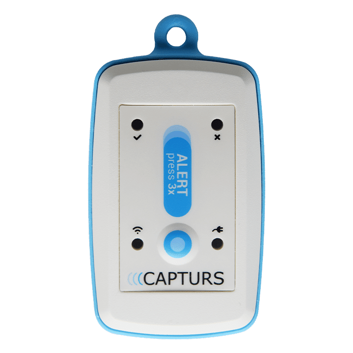
Ein eleganter GPS-Tracker, der klein, leicht und einfach zu tragen ist.
Capturs GPS-Tracker ist transportabel und ideal für die Verfolgung von Personen.
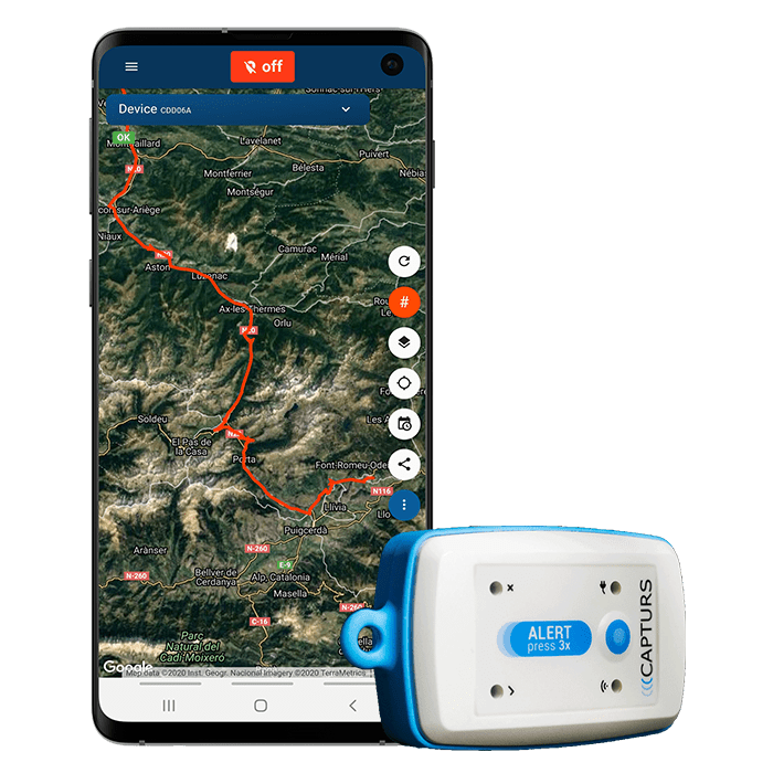
▶️ Verfolgung in Echtzeit
Live-Positionen werden mit der programmierten Frequenz gesendet. In der Grundkonfiguration des GPS-Trackers Modell B wird alle 10 Minuten eine Position gesendet (Flugbahngenauigkeit von ca. 1 Punkt alle 3 Minuten). Sie können die Konfiguration manuell mit der Capturs-Software ändern.
Eine globale Ansicht ermöglicht es Ihnen, den Standort aller Capturs GPS-Tracker zur gleichen Zeit zu sehen (unabhängig vom Modell). Nutzen Sie die Vorteile einer detaillierten Ansicht jedes Ihrer Capturs GPS-Tracker, die Ihnen Informationen sowie alle zugehörigen Trajektorien und Haltepunkte in Echtzeit auf der Capturs-Schnittstelle (mobile Anwendung oder Web-Plattform) liefert.
Die Positionen und Trajektorien können im GPX-Format von der Capturs-Plattform exportiert werden.
▶️ Sigfox-Netzwerk
Der GPS-Tracker Capturs Model B verwendet das Sigfox Ultra-Narrow-Band-Netzwerk für das Internet der Dinge. Wählen Sie beim Kauf die Anzahl der Jahre des erforderlichen Abonnements. Sehen Sie sich die Sigfox-Abdeckungskarte an.
▶️ Lebensdauer der Batterie
Die Batterielebensdauer des Capturs Model B GPS-Trackers variiert von mehreren Wochen bis zu mehreren Monaten, abhängig von der Nutzung und der Anzahl der pro Tag gesendeten Positionen.
▶️ Nachladen
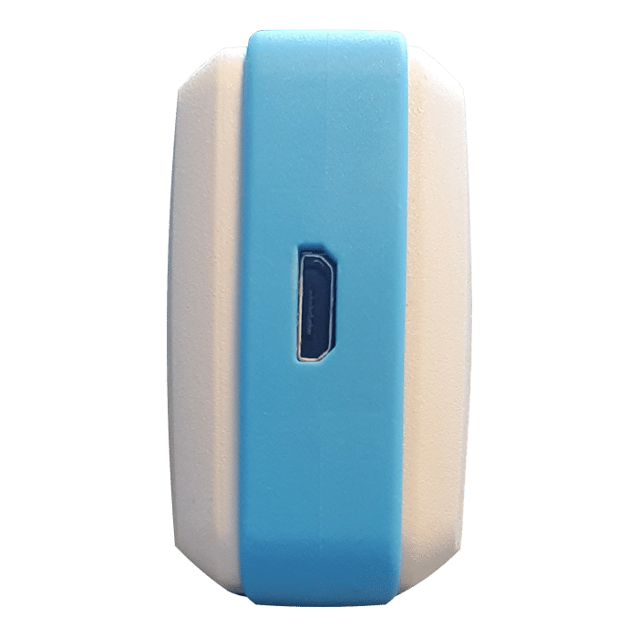
Laden Sie Ihren GPS-Tracker Model B ganz einfach mit dem Micro-USB-Kabel auf.
▶️ Wasserabdichtung
Mit dem GPS-Tracker Model B wird eine wasserdichte Tasche geliefert.
▶️ Datenexport über die Software Capturs
Laden Sie die Capturs-Software herunter, die über mehrere Funktionen verfügt: Exportieren Sie Ihre Daten, aktualisieren Sie sie, konfigurieren Sie den GPS-Tracker und sammeln Sie die in der Bake aufgezeichneten Positionen (Genauigkeit 1 Position/3min), um Ihre Flugrouten genau zu sehen.
▶️ SMS- und/oder E-Mail-Warnungen erstellen
Konfigurieren Sie verschiedene Arten von SMS-/E-Mail-Benachrichtigungen über die Capturs-Benutzeroberfläche: Zoneneintritt, Zonenaustritt, Bewegungserkennung, Immobilität, Abwesenheit, Stromausfall, schwache Batterie, 3-Klick-Benachrichtigung und Tastenklick (mehrere Tastenklick-Anpassungen). Sie können den Inhalt der Alarme ändern und die Empfänger Ihrer Wahl eingeben.
▶️ Kursverläufe und Positionen teilen
Generieren Sie selbst einzigartige URLs und teilen Sie diese mit beliebig vielen Personen. Ändern Sie Parameter und behalten Sie die Kontrolle: Aktivierung/Deaktivierung, Löschung, Dauer des gemeinsamen Pfads usw.
▶️ Erweiterte Analysen generieren
Erstellen Sie automatische Berichte zu allen Ereignissen auf Ihren Capturs GPS-Trackern: Positionen, Alarme, Zonen, Bewegungen, Stopps, Temperatur usw. Erstellen Sie benutzerdefinierte Dashboards und Diagramme. Exportieren Sie Daten im CSV-Format zur weiteren Verarbeitung.
▶️ Berichte über Zonenein- und -ausgänge
Erstellen Sie Ihre eigenen virtuellen Zonen mit unserem Tool zur Erstellung individueller Zonen. Zeigen Sie Ihre Zonen auf der Karte in verschiedenen Farben an. Verknüpfen Sie diese Zonen mit Warnmeldungen, um Nachrichten zu erhalten, wenn ein GPS-Tracker eine Zone betritt oder verlässt. Erstellen Sie automatische Berichte über das Betreten und Verlassen von Zonen und exportieren Sie diese zur Datenanalyse.
Länge 68mm | Breite 42mm | Dicke 24mm
Gewicht 60g
Stromversorgung über Micro-USB-Kabel
Sigfox-Netzwerk
1 Position alle 10min – Konfigurierbar
Der GPS-Tracker Capturs Model B eignet sich ideal für die Ortung von Personen, da er leicht unabhängig getragen und in eine Tasche gesteckt werden kann: Sportortung, Ortung einzelner Personen, Ortung von Mitarbeitern. Er kann auch zum Aufspüren von Vermögenswerten oder jeder anderen Art von Vermögenswerten verwendet werden.
Es kann auch zur Verfolgung von Vermögenswerten oder jeder Art von Objekten verwendet werden.
Die Capturs-Plattform: einfach und leistungsstark
Greifen Sie von Ihrem Computer, Tablet oder Smartphone aus auf die Connect-Schnittstelle oder die mobile Capturs-Anwendung zu.
Erfahren Sie mehr über die Echtzeit-Tracking-Plattform Capturs und alle damit verbundenen Funktionen.
Greifen Sie über Ihr Smartphone (App verfügbar für Android und IoS), Tablet oder Computer auf die Capturs-Plattform zu.
Verwalten Sie alle Ihre GPS-Tracker in Echtzeit, stellen Sie Alarme ein, erstellen Sie unendlich viele benutzerdefinierte Zonen und generieren Sie Berichte für eine gründliche und detaillierte Analyse.
Capturs Software, um weiter zu gehen.
Laden Sie die Capturs-Software auf Ihren Computer herunter und schließen Sie den Capturs-GPS-Tracker über das mitgelieferte Mikro-USB-Kabel an. Aktualisieren Sie die Firmware Ihres Trackers, rufen Sie die Daten ab und exportieren Sie sie nach Belieben.

Frequently asked questions.
Um mehr über den Capturs Model B GPS-Tracker zu erfahren, kontaktieren Sie uns oder konsultieren Sie die FAQ.
Model B Capturs tracker
2 – Click on the button + to access to the addition of the new device.
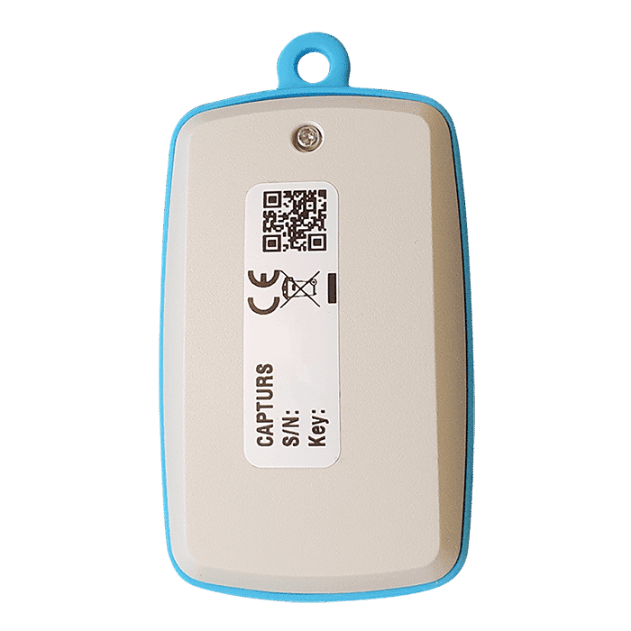
3 – Complete the serial number (S/N) and the activation key (Key) indicated on the back of the device.
(It is normal that the first letter (A or B) of the S/N does not then appear in the device name because it is the device’s model indicator.)
or
Click on the QR code icon and scan the back of the device.
Capturs GPS trackers can only be registered to one user account. If you try to add them to a second account, this message will appear. You will need to delete it from the old account before you can register it to a new one.
2 – To change the name of your GPS tracker, click on the icon

3 – To change the picture of your GPS tracker, click on the icon


To configure the time intervals of the GPS tracker Model B (or Model A) messages, it is necessary to have the Capturs software for PC/Mac and to connect the device to the computer via USB cable.
The Capturs software for PC and Mac is available for download on this page.
The Capturs software is essential for the configuration of your device and the export to your Capturs space of the tracks recorded via the logger.
2 – Go to “Settings” at the top in the middle of the menu.
3 – You will be able to choose the time intervals.
The interval between messages, corresponds to the time between the data sent by the GPS tracker via the Sigfox network.
The interval between GPS positions, corresponds to the time between the fixed position by the GPS tracker, and thus the time interval of the GPS tracker.

The Capturs software for PC and Mac is available for download on this page.
The Capturs software is essential for the configuration of your device and the export to your Capturs space of the tracks recorded via the logger.
In order to send an alert, you have to create one and configure it.
Enter the email addresses and/or phone numbers of your relatives in the configuration of your alert.
To send an alert, you must be in an area covered by the Sigfox network or by GSM (depending on the model).
2 – Choose the GPS tracker you want to configure.
3 – To create a new alert, click on

4 – Click on the icon

Possible configurations:
– Add a name to the alert.
– Enable automatic reactivation of the alert.
– Create time slots for triggering alerts.
– Choose the type of sending of the alert (SMS, Email, API Callback)
Alert content:
– Add one or more Emails, phone numbers, etc..
– Customize the subject and content of the alert as you wish.
– Check the “Share link activated” case if you want to share your tracking link in the alert.
For area alerts:
– Customize the zones by pressing the dots around the red zone.
– Create round or polygonal areas.
– Capturs Systems Connect specific: select an area already registered in the library.

Just click on the button in the middle of the GPS tracker according to the chosen alert (1 click, 2 clicks, 4 clicks or a long click). The blue led at the bottom left of the GPS tracker will blink as many times as you clicked on the button.
If it is the 3 clicks alert :
In the case of the 3-click alert, there is an acknowledgement function: after pressing the button 3 times, the “red” and “green” leds will start flashing alternately until the acknowledgement is received, where the green led will flash rapidly. If this is not the case, the red led will blink quickly and the GPS tracker will try to send the alert again 10 minutes later and start blinking alternately until validation or not of the data reception.
If it is a area alert:
Your alert is sent automatically when your GPS tracker (device or smartphone) enters or leaves the area you have configured.
If it is a motion alert:
When your device is stationary and hasn’t moved for a while, your motion alert will be triggered when the tracker’s motion is detected.
If it is a no motion alert:
An alert will be sent when the GPS tracker has been stationary for a set time.
If it is a low battery alert:
An alert will be sent when the battery is less than 20% of its capacity.
If it is a power-off alert:
An alert will be sent when the GPS tracker is turned off, i.e. when someone turns it off.
If it is an unplugging alert:
An alert will be sent when the GPS tracker is unplungged.
If it is an absence alert:
An alert will be sent when the GPS tracker is not present in a predefined area at the scheduled time.
If it is a temperature alert:
An alert will be sent when the temperature is below or above a certain set temperature threshold.
To start a live tracking using your Capturs GSP tracker, you need to have it registered on your Capturs account and to have an active subscription for real-time data transmission.
2 – Click on the button + to access to the addition of the new device.
3 – Complete the serial number (S/N) and the activation key (Key) indicated on the back of the device.
(It is normal that the first letter (A or B) of the S/N does not then appear in the device name because it is the device’s model indicator.)
or
Click on the QR code icon and scan the back of the device.
Capturs GPS trackers can only be registered to one user account. If you try to add them to a second account, this message will appear. You will need to delete it from the old account before you can register it to a new one.
Then simply take it with you or fix/place it. The device must be on and with battery to send its position when it is in motion.
The Capturs OBD GPS Tracker must be connected to the vehicle’s OBD II socket and the Capturs Power GPS Tracker must be connected to the vehicle battery.
If the GPS trackers are transmitting well but no positions are being sent at the same time, this may be due to several phenomena specific to devices using satellite positioning systems.
The main losses of positions come from the signals dropping out between the GPS tracker and the satellites, thus preventing the triangulation of the position:
– From GPS fix just after departure, cold, where the GPS plotter could not see the constellation of satellites, and therefore needed about 3 minutes before starting to move to find the position and thus start to fix its position correctly.
– The outdoor environment: trees, buildings and even clouds can prevent the proper reception of data from a satellite and may cause triangulation to be prevented or accuracy to be lost.
GPS Tracker Model B:
A simple press on the central button of the tracker allows it to be switched on, if there is enough battery, and to start sending positions in real time.
To turn off the tracker, you must keep the button pressed for about 5 seconds. The leds of the tracker will have the following behaviour: after 3 seconds the blue led will light up, then by keeping pressed, the red led will light up about 2 seconds later. You can release the button when the tracker is off.
GPS Tracker Model C/C Beehive:
If the battery is inserted, the GPS tracker starts automatically. If a tab is fitted to the GPS tracker, gently pull it out and gently tighten the 4 screws (standard Model C) to close the case properly.
To turn off the GPS tracker, remove the battery.
GPS Tracker OBD:
To turn the GPS tracker on and off, simply plug and unplug it from the vehicle’s OBD II socket.
GPS Tracker Power:
To turn the GPS tracker on and off, simply plug and unplug it from the vehicle’s battery.
GPS Tracker Performance GSM:
To switch the GPS tracker on and off, simply press and hold the button on the edge for about 5 seconds.
GPS Tracker Endurance GSM/Mini:
To switch the GPS tracker on and off, open the case and press the ON/OFF switch located inside.
To update the firmware of the GPS tracker, it is necessary to have the Capturs software for PC/Mac and to connect the GPS tracker to the computer via USB cable.
The Capturs software for PC and Mac is available for download on this page.
The Capturs software is essential for the configuration of your device and the export to your Capturs space of the tracks recorded via the logger.
2 – Go to “Advanced Settings” at the top right of the menu.
3 – This will allow you to update the GPS tracker if it does not already have the latest version.
To configure the “flight mode” or 3D of the GPS tracker Model B, it is necessary to have the Capturs software for PC/Mac and to connect the GPs tracker to the computer via USB cable.
The Capturs software for PC and Mac is available for download on this page.
The Capturs software is essential for the configuration of your device and the export to your Capturs space of the tracks recorded via the logger.
2 – Go to “Settings” at the top middle of the menu and you will be able to choose this parameter.
When the “flight mode” or 3D mode of the GPs tracker is deactivated, it will send previous positions of the device, allowing real-time tracking with an accuracy of about 3 minutes. And when it is activated, the GPS tracker will send its speed and altitude when sending the last known position.
The logger of the Model B GPS tracker allows the recording of positions closer than the positions sent in real time thanks to the Sigfox network.
In order to retrieve these recorded positions, it is necessary to connect the GPS tracker with the USB cable to a PC/Mac and launch the Capturs software. And thanks to the software and the computer’s internet connection, the recorded positions are retrieved and then visible on the web and mobile interface.
The Capturs software for PC and Mac is available for download on this page.
The Capturs software is essential for the configuration of your device and the export to your Capturs space of the tracks recorded via the logger.
Battery life varies according to the use and stops of the Capturs GPS trackers. It can also vary according to the configurations made by our teams or by yourself on the Capturs software (only available for the Model B or Model A). It can be up to several months/years.
The battery life of the Capturs OBD and POWER GPS trackers is unlimited as it is linked to that of the vehicle.
| GPS tracker model | Estimated battery life |
| Model B Performance GSM |
★★★★☆ |
| Model C Model C Beehive Endurance GSM Mini |
★★★★★ |
| OBD Power |
ထ |
Estimated battery life by model :
Model B
Performance GSM
★★★★☆
Model C
Model C Beehive
Endurance GSM
Mini
★★★★★
OBD
Power
ထ
| Model B | 68 x 42 x 24 mm | 55g |
| Model C | 75 x 75 x 35 mm | 60g |
| Model C Beehive | 87 x 57 x 24 mm | 60g |
| Performance GSM | 39 x 26 x 77 mm | 93g |
| Endurance GSM | 85 x 49 x 30 mm | 140g |
| Mini | 64 x 50 x 22 mm | 82g |
| OBD | 48 x 48 x 22 mm | 58g |
| Power | 135 x 65 x 15 mm | 130g |
Model B GPS tracker: Measures 68x42x24mm and weighs 55g.
Model C GPS tracker: Measures 75x75x35mm and weighs 60g.
Model C Beehive GPS tracker: Measures 87x57x24mm and weighs 60g.
Performance GSM GPS tracker: Measures 39x26x77mm and weighs 93g.
Endurance GSM GPS tracker: Measures 85x49x30mm and weighs 140g.
Mini GPS tracker: Measures 64x50x22mm and weighs 82g.
OBD GPS tracker: Measures 48x48x22mm and weighs 58g.
Power GPS tracker: Measures 135x65x15mm and weighs 130g.
Behaviour of the LEDs during charging:
Model B: ● fixed: charging | ● fixed: charging is complete
Performance GSM: ● flashes rapidly: charging | ● fixed: charging is complete
To find out the battery percentage of your GPS tracker, log on to the web platform or the application.
In “My Devices”:
In the left menu, “Devices” then “My Devices”, you can see the information of your GPS tracker and its battery percentage.
On the map:
Select the GPS tracker for which you want to know the information in the top blue box.

Click on the icon

“Low battery” alert:
Create a low battery alert. The alert will be triggered when the battery is at less than 20% of its capacity and you will receive an SMS or email, depending on the configuration of your alert.
A metallic environment disturbs Sigfox radio waves and can lead to signal losses. Do not use Sensors near or surrounded by a large metal object (water bottle).
GPS Fix
When it hasn’t been working for some time, the GPS needs to know the satellite constellation. It will automatically download the ephemeris and store it in its memory to get its position faster in the next fix. The first fix can thus be longer depending on the environment. A clear environment during the first fix will improve system performance. The ephemeris is valid for about 4 hours.
GPS does not work indoors. The Sigfox network, on the other hand, will often be operational. Movement information without position indications can thus be used in the software in a transparent way for the user, thus increasing its capacities. An approximate position can also be given by radio triangulation.
GPS tracker position
Position the GPS tracker preferably with the eyelet facing up and the face with the Capturs Logo facing out. Do not attach the GPS tracker to the eyelet as the vibratory motion of the pendulum will affect performance. The ideal is an external backpack pocket, such as a mesh pocket that is well maintained in the indicated position. Otherwise, position the GPS tracker with the face with the Capturs logo facing upwards.
Wearing the GPs tracker on a person
The principle of radio waves emission applies: the less obstacles we have, i.e. the more we are facing a free field, the better the result will be.
Thus on a person, the ideal is to carry it in an external pocket of the backpack or on the belt well maintained in the right direction, following the principles of positioning explained in the previous paragraphs. Avoid places where the beacon moves in all directions, turns over, vibrates too much or undergoes a continuous pendulum movement.
The GPS tracker will also work in pockets or bags, as the environment may have an influence. A metal frame or formwork will greatly degrade radio performance.
The higher the GPS tracker is carried, with no obstructions around it, and is well maintained, the better the result will be.
The Model B (and A) Capturs GPS tracker is not waterproof and has no IP certification, but we provide with each GPS tracker a waterproof pouch that allows the GPS tracker to be sheltered from water.
The Model C Capturs, Endurance GSM, Mini and Power GPS trackers are certified IP67. They are waterproof, dustproof and weather resistant.
Please note that the Model C Beehive GPS tracker is not waterproof, unlike the standard Model C.
The GPS tracker Capturs Performance GSM is IPX5 certified. It is protected against water splashes from all directions.
| Turn on |
● fixed ● flashes once |
| Turn off |
● fixed ● flashes once |
| 1 click alert | ● flashes once |
| 2 clicks alert | ● flashes twice |
| 4 clicks alert | ● flashes four times |
| 3 clicks alert |
●● flash in alternation ● flashes three times |
| Sending a Sigfox message | ● fixed 6 seconds during the Sigfox transmission |
| Successful GPS fix | ● flashes once |
| Failed GPS fix | ● flashes once |
| Battery recharging |
● fixed : recharging ● fixed : recharging is complete |
Turn on:
● fixed
● flashes once
Turn off:
● fixed
● flashes once
1 click alert:
● flashes once
2 clicks alert:
● flashes twice
4 clicks alert:
● flashes four times
3 clicks alert:
●● flash in alternation
● flashes three times
Sending a Sigfox message:
● fixed 6 seconds during the Sigfox transmission
Successful GPS fix:
● flashes once
Failed GPS fix:
● flashes once
Battery recharging:
● fixed: recharging
● fixed: recharging is complete
| Model B | Live geolocation: 10 min / Tracking accuracy: 3 min (1) |
| Model C / C Beehive | Live geolocation: 15 min / Tracking accuracy: 5 min |
| Performance GSM | Live geolocation: 60 s / Tracking accuracy: 60 s (2) |
| Endurance GSM | Live geolocation: 2 positions/day / Tracking accuracy: 2 positions/day (2) |
| Mini | Live geolocation: 2 positions/day / Tracking accuracy: 2 positions/day (2) |
| OBD | Live geolocation: 30 s / Tracking accuracy: 30 s |
| Power | Live geolocation: 30 s / Tracking accuracy: 30 s |
(2) It is possible to change this frequency through our support team. Please note that the higher the frequency, the less time the battery will last.
Model B:
Live geolocation: 10min / Tracking accuracy: 3min (1)
Model C / C Beehive:
Live geolocation: 15min / Tracking accuracy: 5min
Performance GSM:
Live geolocation: 60s / Tracking accuracy: 60s (2)
Endurance GSM:
Live geolocation: 2 positions/day / Tracking accuracy: 2 positions/day (2)
Mini:
Live geolocation: 2 positions/day / Tracking accuracy: 2 positions/day (2)
OBD:
Live geolocation: 30s / Tracking accuracy: 30s
Power:
Live geolocation: 30s / Tracking accuracy: 30s
(1) It is possible to increase this frequency in the PC/Mac Capturs software by connecting your Model B GPS tracker to your computer.
(2) It is possible to change this frequency through our support team. Please note that the higher the frequency, the less time the battery will last.
You can send different types of alerts depending on your tracker.
Model B (or A) GPS tracker: Area entry, area exit, motion detection, no motion, powering-Off, absence, 3 press button, 1 press button, 2 press button, 4 press button, 1 long press button and low battery.
Model C GPS tracker: Area entry, area exit, motion detection, no motion, absence, low battery.
Performance GSM, Endurance GSM, Mini GSM GPS trackers: Area entry, area exit, motion detection, no motion, absence, low battery, 1 long press button.
OBD GSM, Power GSM GPS trackers: Area entry, area exit, motion detection, no motion, absence, unpluging.
Smartphone tracker via Capturs application: Area entry, area exit, motion detection, no motion.
Capturs Systems Connect interface specific functions
How do I access it?
1 – On the Capturs interface, open the left menu and click on Analytics.
2 – Go to the advanced analyses: select date, zone and tracker. Scroll through the different tables and graphs by clicking on < > at the bottom of the page. Click on Google Data Studio at the bottom of this page for additional analyses.
You don’t have access to this feature? Contact support@capturs.com.
2 – Click on the button + to access to the addition of the new area.
3 – Create a specific area by moving the points that surround it, give it a name, a color and validate. Create all the areas you need this way.
4 – All the areas you created are now on the map at the top of this same page. They are also saved in the library of your account in order to reuse them by creating area alerts.
5 – The check in / check out table is at the bottom of the same page. It allows you to have precise data on the trackers that have entered or left these areas, as well as the times and dates.
2 – Select a tracker in the search bar to bring up the table.
3 – Click on

4 – You can now analyze the table and graphs that correspond to the raw data emitted by your tracker. These are doubts the data sent by the tracker to each event received by the tracker.
Points of Interest (POIs) are your own landmarks. You can easily create them by entering a street address or by pointing to the map. They will be displayed on the map if you select the “points of interest” icon on the right side of the screen. Also, easily find your points of interest on the map by filtering them using the top bar that appears when you have saved POIs.
With the “Labels” tool, customize your points of interest even better by categorizing them with colors.
When you click on 
2 – You have access to the following reports: alerts, check-in/out, raw data, stop points and analytics.
3 – You can export the data by clicking on CSV EXPORT.
Das Sigfox LPWAN-Netzwerk.
Das Sigfox-Netzwerk ist ein drahtloses Netzwerk mit geringem Stromverbrauch und großer Reichweite. Siehe die Karte der Sigfox-Netzwerkabdeckung.

Länder, die im Sigfox-Abonnement enthalten sind: Belgien, Bulgarien, Dänemark, Deutschland, Estland, Finnland, Frankreich, Griechenland, Irland, Italien, Kroatien, Lettland, Liechtenstein, Litauen, Luxemburg, Malta, Niederlande, Österreich, Polen, Portugal, Rumänien, Schweden, Schweiz, Spanien, Vereinigtes Königreich, Serbien, Slowakei, Slowenien, Tschechische Republik, Ungarn, Französisch-Guayana, Französisch-Polynesien, Guadeloupe, Martinique, Mayotte, Neukaledonien, Reunion, Südafrika, Botswana, Kenia, Mauritius, Nigeria, Oman, Senegal, Swasiland, Vereinigte Arabische Emirate.