GPS tracker Capturs Power GSM
129€ excl. VAT
+ choice of SIM card subscription (Europe/World)
Or pay 4x free of charge with ![]()
● Capturs Power GSM GPS tracker
● Multi-operator SIM card GSM – LTE
● “High Performance” Subscription – 1 point every 30s max.
● Access to the Capturs premium platform/application and API
● 20 SMS
● Multi-operator SIM card GSM – LTE
● “High Performance” Subscription – 1 point every 30s max.
● Europe or Worldwide
● 1 year without commitment. For a shorter or longer subscription, please contact us.
● Capturs Power GSM GPS tracker: 129€ excl. VAT per unit
● Europe subscription: 6,99€ excl. VAT/month (83,88€ excl. VAT/year)
● Worldwide subscription (option) : 19,99€ excl. VAT/month (239,88€ excl. VAT/year)
⚠ Volume discounts: contact us
All included ✓
Activated multi-operator SIM card included when shipping
Benefit from the best of the GSM network and all the operators available in Europe or in World according to the choice of SIM card.

Consult
technical sheet

Questions?
Contact us

Multi-operator
SIM card included

GSM network (all operators included)

Volume discounts: please specify
Consult technical sheet
Questions? Contact us
Multi-operator SIM card included
GSM network (all operators included)
Volume discounts: please specify
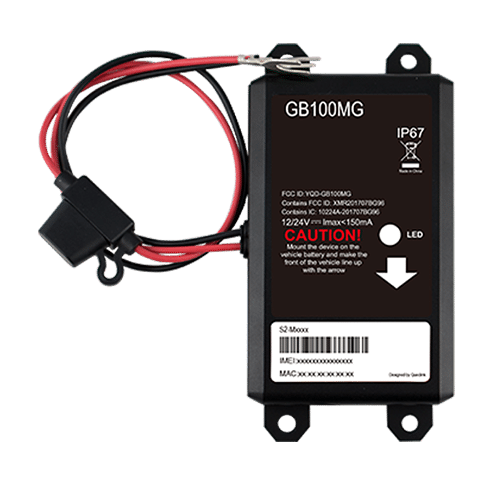
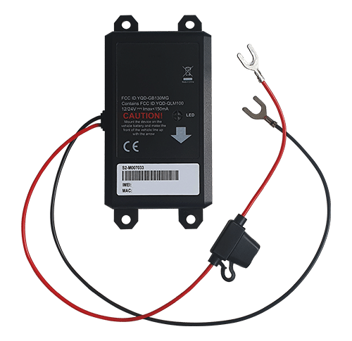
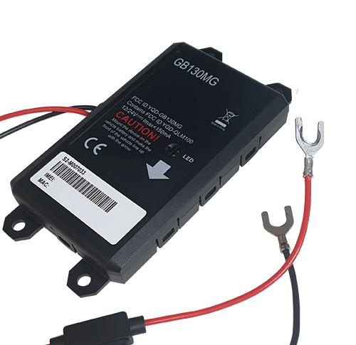
A concealed, ultra-precise GPS tracker connected to your vehicle.
The GPS tracker connects to the battery of vehicles/boats requiring long-term tracking.
▶️ Real-time tracking
Live positions are sent at the programmed frequency. The basic configuration of the Power GSM GPS tracker is 1 position sent every 30 seconds (we can manually change this configuration by spacing the intervals as required).
A global view lets you know the location of all your Capturs GPS trackers at the same time (regardless of model). Take advantage of a detailed view of each of your Capturs GPS trackers, providing you with information as well as all associated trajectories and stopping points, in real time on the Capturs interface (mobile application or web platform).
Positions and trajectories can be exported in GPX format from the Capturs platform.
▶️ GSM LTE network
We provide multi-operator SIM cards that are pre-installed and activated in your GPS trackers upon dispatch. The Power GSM Capturs GPS tracker uses the GSM LTE network.
▶️ Battery life
The battery life of the Capturs Power GSM GPS tracker is unlimited, as it is powered by the vehicle’s battery. It is connected directly to the + and – poles of the vehicle/boat battery. A 200mA NiMH backup battery ensures tracking continuity even if the power supply is disconnected.
▶️ Waterproofing
The GPS tracker is IP67-rated: no dust penetration, full protection against contact (dustproof). No water penetration when submerged to a depth of 1 meter for 30 minutes.
▶️ Create SMS and/or Email alerts
Configure several types of SMS/Email alerts from the Capturs interface: zone entry, zone exit, motion detection, immobility, absence and disconnection. You can modify the content of alerts and enter the recipients of your choice.
▶️ Share trajectories and positions
Generate unique URLs yourself and share them with as many people as you like. Modify parameters and stay in control: activation/deactivation, deletion, duration of shared path, etc.
▶️ Generate advanced analyses
Generate automatic reports corresponding to all your Capturs GPS tracker events: positions, alerts, zones, movements, stops, etc. Create customized dashboards and graphs. Export data in CSV format for further processing.
▶️ A calendar of your stops
Stops on your Capturs GPS trackers are referenced via a table, but also in the form of an easy-to-understand and easy-to-analyze diary. Analyze stopping and moving times, schedules, physical addresses and zones associated with stops.
▶️ Zone entry and exit reports
Create your own virtual zones using our customized zone creation tool. On the map, visualize your zones in different colors. Associate these zones with alerts to receive messages when a GPS tracker enters or leaves a zone. Generate zone entry and exit reports automatically, and export them for data analysis.
Length 135mm | Width 65mm | Thickness 15mm
Weight 130g
Powered by the + and – poles of the vehicle/boat battery
GSM LTE network
1 point every 30 seconds max – Configurable at customer request
Unlimited autonomy
Ultra-precise tracking and monitoring of vehicles over long distances: fleet tracking, trip management, calculating distances and times on the road, etc.
Can also be used to combat theft, as the GPS Power GSM tracker is concealed.
The Capturs platform: simple and powerful
From your computer, tablet or smartphone, access the Connect interface or the Capturs mobile application.


Find out more about the Capturs real-time tracking platform and all the associated features.
Access the Capturs platform from your smartphone (app available on Android and IoS), tablet or computer.
Manage all your GPS trackers in real time, set alerts, create infinite custom zones and generate reports for in-depth and detailed analysis.
Frequently asked questions.
To find out more about the Capturs Power GSM GPS Tracker, contact us or consult the FAQ.
GPS tracker Capturs Power GSM
2 – Click on the button + to access to the addition of the new device.
3 – Complete the serial number (S/N) and the activation key (Key) indicated on the back of the device.
(It is normal that the first letter (A or B) of the S/N does not then appear in the device name because it is the device’s model indicator.)
or
Click on the QR code icon and scan the back of the device.
Capturs GPS trackers can only be registered to one user account. If you try to add them to a second account, this message will appear. You will need to delete it from the old account before you can register it to a new one.
2 – To change the name of your GPS tracker, click on the icon

3 – To change the picture of your GPS tracker, click on the icon


In order to send an alert, you have to create one and configure it.
Enter the email addresses and/or phone numbers of your relatives in the configuration of your alert.
To send an alert, you must be in an area covered by the Sigfox network or by GSM (depending on the model).
2 – Choose the GPS tracker you want to configure.
3 – To create a new alert, click on

4 – Click on the icon

Possible configurations:
– Add a name to the alert.
– Enable automatic reactivation of the alert.
– Create time slots for triggering alerts.
– Choose the type of sending of the alert (SMS, Email, API Callback)
Alert content:
– Add one or more Emails, phone numbers, etc..
– Customize the subject and content of the alert as you wish.
– Check the “Share link activated” case if you want to share your tracking link in the alert.
For area alerts:
– Customize the zones by pressing the dots around the red zone.
– Create round or polygonal areas.
– Capturs Systems Connect specific: select an area already registered in the library.

Just click on the button in the middle of the GPS tracker according to the chosen alert (1 click, 2 clicks, 4 clicks or a long click). The blue led at the bottom left of the GPS tracker will blink as many times as you clicked on the button.
If it is the 3 clicks alert :
In the case of the 3-click alert, there is an acknowledgement function: after pressing the button 3 times, the “red” and “green” leds will start flashing alternately until the acknowledgement is received, where the green led will flash rapidly. If this is not the case, the red led will blink quickly and the GPS tracker will try to send the alert again 10 minutes later and start blinking alternately until validation or not of the data reception.
If it is a area alert:
Your alert is sent automatically when your GPS tracker (device or smartphone) enters or leaves the area you have configured.
If it is a motion alert:
When your device is stationary and hasn’t moved for a while, your motion alert will be triggered when the tracker’s motion is detected.
If it is a no motion alert:
An alert will be sent when the GPS tracker has been stationary for a set time.
If it is a low battery alert:
An alert will be sent when the battery is less than 20% of its capacity.
If it is a power-off alert:
An alert will be sent when the GPS tracker is turned off, i.e. when someone turns it off.
If it is an unplugging alert:
An alert will be sent when the GPS tracker is unplungged.
If it is an absence alert:
An alert will be sent when the GPS tracker is not present in a predefined area at the scheduled time.
If it is a temperature alert:
An alert will be sent when the temperature is below or above a certain set temperature threshold.
To start a live tracking using your Capturs GSP tracker, you need to have it registered on your Capturs account and to have an active subscription for real-time data transmission.
2 – Click on the button + to access to the addition of the new device.
3 – Complete the serial number (S/N) and the activation key (Key) indicated on the back of the device.
(It is normal that the first letter (A or B) of the S/N does not then appear in the device name because it is the device’s model indicator.)
or
Click on the QR code icon and scan the back of the device.
Capturs GPS trackers can only be registered to one user account. If you try to add them to a second account, this message will appear. You will need to delete it from the old account before you can register it to a new one.
Then simply take it with you or fix/place it. The device must be on and with battery to send its position when it is in motion.
The Capturs OBD GPS Tracker must be connected to the vehicle’s OBD II socket and the Capturs Power GPS Tracker must be connected to the vehicle battery.
If the GPS trackers are transmitting well but no positions are being sent at the same time, this may be due to several phenomena specific to devices using satellite positioning systems.
The main losses of positions come from the signals dropping out between the GPS tracker and the satellites, thus preventing the triangulation of the position:
– From GPS fix just after departure, cold, where the GPS plotter could not see the constellation of satellites, and therefore needed about 3 minutes before starting to move to find the position and thus start to fix its position correctly.
– The outdoor environment: trees, buildings and even clouds can prevent the proper reception of data from a satellite and may cause triangulation to be prevented or accuracy to be lost.
GPS Tracker Model B:
A simple press on the central button of the tracker allows it to be switched on, if there is enough battery, and to start sending positions in real time.
To turn off the tracker, you must keep the button pressed for about 5 seconds. The leds of the tracker will have the following behaviour: after 3 seconds the blue led will light up, then by keeping pressed, the red led will light up about 2 seconds later. You can release the button when the tracker is off.
GPS Tracker Model C/C Beehive:
If the battery is inserted, the GPS tracker starts automatically. If a tab is fitted to the GPS tracker, gently pull it out and gently tighten the 4 screws (standard Model C) to close the case properly.
To turn off the GPS tracker, remove the battery.
GPS Tracker OBD:
To turn the GPS tracker on and off, simply plug and unplug it from the vehicle’s OBD II socket.
GPS Tracker Power:
To turn the GPS tracker on and off, simply plug and unplug it from the vehicle’s battery.
GPS Tracker Performance GSM:
To switch the GPS tracker on and off, simply press and hold the button on the edge for about 5 seconds.
GPS Tracker Endurance GSM/Mini:
To switch the GPS tracker on and off, open the case and press the ON/OFF switch located inside.
Battery life varies according to the use and stops of the Capturs GPS trackers. It can also vary according to the configurations made by our teams or by yourself on the Capturs software (only available for the Model B or Model A). It can be up to several months/years.
The battery life of the Capturs OBD and POWER GPS trackers is unlimited as it is linked to that of the vehicle.
| GPS tracker model | Estimated battery life |
| Model B Performance GSM |
★★★★☆ |
| Model C Model C Beehive Endurance GSM Mini |
★★★★★ |
| OBD Power |
ထ |
Estimated battery life by model :
Model B
Performance GSM
★★★★☆
Model C
Model C Beehive
Endurance GSM
Mini
★★★★★
OBD
Power
ထ
| Model B | 68 x 42 x 24 mm | 55g |
| Model C | 75 x 75 x 35 mm | 60g |
| Model C Beehive | 87 x 57 x 24 mm | 60g |
| Performance GSM | 39 x 26 x 77 mm | 93g |
| Endurance GSM | 85 x 49 x 30 mm | 140g |
| Mini | 64 x 50 x 22 mm | 82g |
| OBD | 48 x 48 x 22 mm | 58g |
| Power | 135 x 65 x 15 mm | 130g |
Model B GPS tracker: Measures 68x42x24mm and weighs 55g.
Model C GPS tracker: Measures 75x75x35mm and weighs 60g.
Model C Beehive GPS tracker: Measures 87x57x24mm and weighs 60g.
Performance GSM GPS tracker: Measures 39x26x77mm and weighs 93g.
Endurance GSM GPS tracker: Measures 85x49x30mm and weighs 140g.
Mini GPS tracker: Measures 64x50x22mm and weighs 82g.
OBD GPS tracker: Measures 48x48x22mm and weighs 58g.
Power GPS tracker: Measures 135x65x15mm and weighs 130g.
- Locate the vehicle (car, truck, etc.) or boat battery.
- Install the Capturs Power GPS Tracker by connecting it to the battery: connect the black wire to the negative (-) electrode and the red wire to the positive (+) electrode.
- Attach the Capturs Power GPS tracker to the battery using double-sided tape.
- When the LED flashes, the Capturs Power GPS Tracker is powered on.
The Model B (and A) Capturs GPS tracker is not waterproof and has no IP certification, but we provide with each GPS tracker a waterproof pouch that allows the GPS tracker to be sheltered from water.
The Model C Capturs, Endurance GSM, Mini and Power GPS trackers are certified IP67. They are waterproof, dustproof and weather resistant.
Please note that the Model C Beehive GPS tracker is not waterproof, unlike the standard Model C.
The GPS tracker Capturs Performance GSM is IPX5 certified. It is protected against water splashes from all directions.
| Working normally | ● fixed |
| Network, GPS or SIM card not detected/abnormal | ● flash |
| Power off or sleep mode | ● dark |
● fixed: Working normally
● flash: Network, GPS or SIM card not detected/abnormal
● dark: Power off or sleep mode
| Model B | Live geolocation: 10 min / Tracking accuracy: 3 min (1) |
| Model C / C Beehive | Live geolocation: 15 min / Tracking accuracy: 5 min |
| Performance GSM | Live geolocation: 60 s / Tracking accuracy: 60 s (2) |
| Endurance GSM | Live geolocation: 2 positions/day / Tracking accuracy: 2 positions/day (2) |
| Mini | Live geolocation: 2 positions/day / Tracking accuracy: 2 positions/day (2) |
| OBD | Live geolocation: 30 s / Tracking accuracy: 30 s |
| Power | Live geolocation: 30 s / Tracking accuracy: 30 s |
(2) It is possible to change this frequency through our support team. Please note that the higher the frequency, the less time the battery will last.
Model B:
Live geolocation: 10min / Tracking accuracy: 3min (1)
Model C / C Beehive:
Live geolocation: 15min / Tracking accuracy: 5min
Performance GSM:
Live geolocation: 60s / Tracking accuracy: 60s (2)
Endurance GSM:
Live geolocation: 2 positions/day / Tracking accuracy: 2 positions/day (2)
Mini:
Live geolocation: 2 positions/day / Tracking accuracy: 2 positions/day (2)
OBD:
Live geolocation: 30s / Tracking accuracy: 30s
Power:
Live geolocation: 30s / Tracking accuracy: 30s
(1) It is possible to increase this frequency in the PC/Mac Capturs software by connecting your Model B GPS tracker to your computer.
(2) It is possible to change this frequency through our support team. Please note that the higher the frequency, the less time the battery will last.
You can send different types of alerts depending on your tracker.
Model B (or A) GPS tracker: Area entry, area exit, motion detection, no motion, powering-Off, absence, 3 press button, 1 press button, 2 press button, 4 press button, 1 long press button and low battery.
Model C GPS tracker: Area entry, area exit, motion detection, no motion, absence, low battery.
Performance GSM, Endurance GSM, Mini GSM GPS trackers: Area entry, area exit, motion detection, no motion, absence, low battery, 1 long press button.
OBD GSM, Power GSM GPS trackers: Area entry, area exit, motion detection, no motion, absence, unpluging.
Smartphone tracker via Capturs application: Area entry, area exit, motion detection, no motion.
Capturs Systems Connect interface specific functions
How do I access it?
1 – On the Capturs interface, open the left menu and click on Analytics.
2 – Go to the advanced analyses: select date, zone and tracker. Scroll through the different tables and graphs by clicking on < > at the bottom of the page. Click on Google Data Studio at the bottom of this page for additional analyses.
You don’t have access to this feature? Contact support@capturs.com.
2 – Click on the button + to access to the addition of the new area.
3 – Create a specific area by moving the points that surround it, give it a name, a color and validate. Create all the areas you need this way.
4 – All the areas you created are now on the map at the top of this same page. They are also saved in the library of your account in order to reuse them by creating area alerts.
5 – The check in / check out table is at the bottom of the same page. It allows you to have precise data on the trackers that have entered or left these areas, as well as the times and dates.
2 – Select a tracker in the search bar to bring up the table.
3 – Click on

4 – You can now analyze the table and graphs that correspond to the raw data emitted by your tracker. These are doubts the data sent by the tracker to each event received by the tracker.
Points of Interest (POIs) are your own landmarks. You can easily create them by entering a street address or by pointing to the map. They will be displayed on the map if you select the “points of interest” icon on the right side of the screen. Also, easily find your points of interest on the map by filtering them using the top bar that appears when you have saved POIs.
With the “Labels” tool, customize your points of interest even better by categorizing them with colors.
When you click on 
2 – You have access to the following reports: alerts, check-in/out, raw data, stop points and analytics.
3 – You can export the data by clicking on CSV EXPORT.
The best of the GSM network.
The best coverage in the world. Choose the right SIM card for your travels: Europe or Worldwide.

Countries included in the Europe SIM subscription: Austria, Belgium, Bosnia and Herzegovina, Bulgaria, Croatia, Cyprus, Czech Republic, Denmark, Estonia, Finland, France, French Guiana, Germany, Gibraltar, Greece, Hungary, Iceland, Ireland, Italy, Kosovo, Lithuania, Luxembourg, Malta, Mayotte, Netherlands, Norway, Poland, Portugal, Réunion, Romania, Slovakia, Slovenia, Spain, Sweden, Switzerland, Ukraine, United Kingdom.
Countries included in the World SIM subscription (including countries in the Europe zone): Afghanistan, Albania, Algeria, Angola, Anguilla, Antigua and Barbuda, Argentina, Armenia, Aruba, Australia, Austria, Azerbaijan, Bahamas, Bahrain, Bangladesh, Barbados, Belarus, Belgium, Belize, Benin, Bermuda, Bhutan, Bolivia,; Bonaire, Bosnia and Herzegovina, Botswana, Brazil, British Vingin Islands, Brunei, Bulgaria, Burkina Faso, Burundi, Cambodia, Cameroon, Canada, Cape verde, Cayman Islands, Central African Republic, Chad, Chile, China, Collectivity of Saint Martin, Colombia, Congo, Costa Rica, Cote d’Ivoire, Croatia, Cyprus, Czech Republic, Democratic Republic of the Congo, Denmark, Dominica, Dominican Republic, Ecuador, Egypt, El Salvador, Equatorial Guinea, Estonia, Faroe Islands, Fiji, Finland, France, French Guiana, French Polynesia, Gabon, Gorgia, Germany, Ghana, Gibraltar, Greece, Greenland, Guam, Guatemala, Guinea, Guinea-Bissau, Guyana, Honduras, Hong Kong, Hungary, Iceland, India, Indonesia, Ireland, Isle of Man, Israel, Italy, Jamaica, Japan, Jersey, Jordan, Kazakhstan, Kenya, Kosovo, Kuwait, Kyrgyzstan, Laos, Latvia, Liberia, Libya, Liechtenstein, Lithuania, Luxembourg, Macau, Madagascar, Malawi, Malta, Martinique, Mauritania, Mauritius, Mayotte, Mexico, Moldova, Mongolia, Montenegro, Montserrat, Morocco, Mozambique, Myanmar, Nauru, Nepal, Netherlands, Netherlands Antilles, New Zealand, Nicaragua, Niger, Nigeria, Northern Mariana Islands, Norway, Oman, Pakistan, Palestinian National Authority, Panama, Papua New Guinea, Paraguay, Peru, Philippines, Poland, Portugal, Puerto Rico, Qatar, Republic of North Macedonia, Réunion, Romania, Russia, Rwanda, Saint Helena Ascension and Tristan da Cunha, Saint Kitts and Nevis, Saint Lucia, Saint Vincent and the Grenadines, Samoa, Saudi Arabia, Senegal, Serbia, Seychelles, Sierra Leone, Singapore, Slovakia, Slovenia, South Africa, South Korea, Spain, Sri Lanka, Suriname, Swaziland, Sweden, Switzerland, Taiwan, Tajikistan, Tanzania, Thailand, The Gambia, Timor-Leste, Togo, Tonga, Trinidad and Tabago, Tunisia, Turkey, Turks and Caicos Islands, Uganda, Ukraine, United Kingdom, United States, Uruguay, Uzbekistan, Venezuela, Vietnam, Yemen, Zambia.